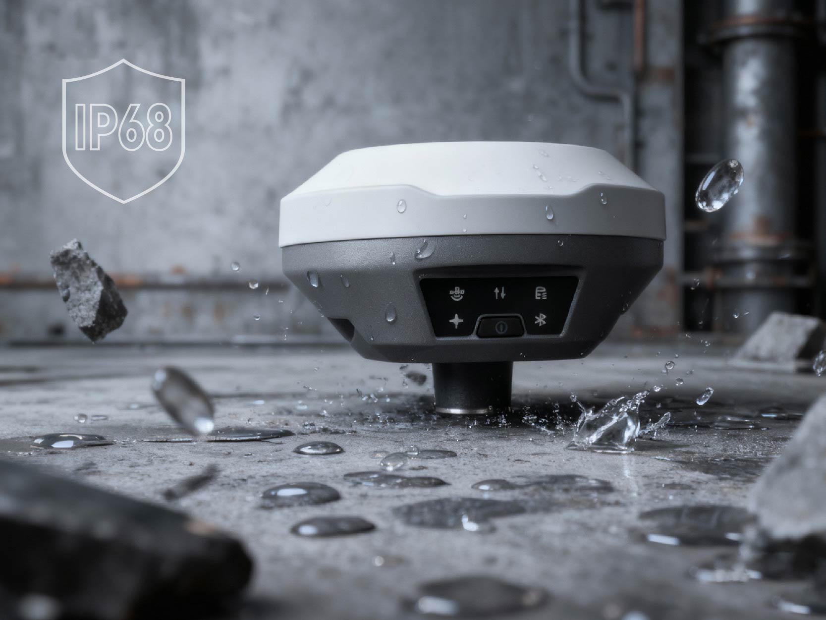
IP68
PPP 2 CM RMS
L1 / L2 / L5
NO CORS NEEDED
L-Base
IP68-rated GNSS receiver with built-in PPP processing. Dust-tight, submersible, field-ready.
Self-converging PPP base station that delivers centimetre-accurate RTK corrections to any GNSS-RTK device — drones, agricultural auto-steer, construction machine control, and survey rovers. Uses commercial L-Band PPP data with 99% availability and dual-satellite coverage worldwide. No CORS subscription needed.
Ongoing costs, limited coverage, infrastructure dependency
Satellite-based, global coverage, no infrastructure
Watch L-Base auto-converge via commercial L-Band PPP corrections with 99% availability and dual-satellite global coverage. Requires open sky to receive L-Band signals. Just place, power on, and work.
Set L-Base on the ground with open sky — clear view of L-Band satellites required. No tripod needed.
Press the button. PPP auto-converges to ITRF2020 centimetre coordinates using commercial L-Band satellite data.
RTK corrections stream to your equipment automatically. 10-hour battery, or plug in USB-C for non-stop operation.
Drones, tractors, graders, survey rovers — L-Base delivers centimetre accuracy where CORS networks don't reach.
Multi-frequency carrier phase eliminates ionospheric delay. Precise orbit & clock corrections resolve ambiguities. Converges in ~5 minutes under open sky.
PPP coordinates locked as base station reference. Generates RTCM 3.x corrections, broadcast as NTRIP stream in real time.
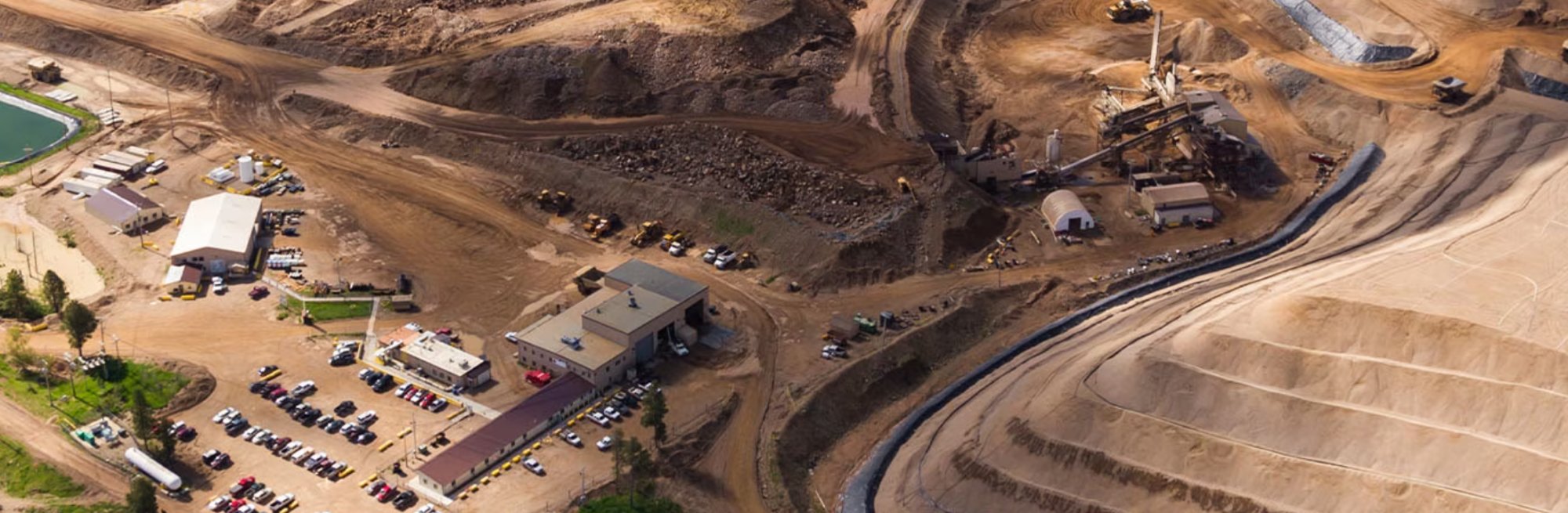
Fly volumetric surveys over mine sites where CORS coverage doesn't exist. L-Base delivers centimetre-accurate corrections from satellite — calculate stockpile volumes with confidence, even at the most remote pit.
Map drainage patterns, plan variable-rate seeding, and verify land boundaries across vast farms. No cellular network needed — L-Base works off-grid in Kazakhstan, Australia, Brazil, or anywhere your fields are.
Monitor earthworks, guide machine control systems, and survey road corridors. L-Base provides RTK corrections for drones, graders, excavators, and survey rovers — without an annual CORS subscription eating your project budget.
| Specification | L-Base + PPP | DJI D-RTK 3 |
|---|---|---|
| Positioning | PPP — no CORS required | Network RTK only — no PPP |
| CORS subscription | Not needed | Recommended for full accuracy |
| Compatible devices | Any RTCM 3.x: drones, tractors, graders, rovers | DJI drones only |
| Ecosystem lock-in | None — open platform | DJI required |
| Broadcast links | Radio · 4G · Remote Controller | DJI proprietary |
| PPP capability | Yes — 2 cm, built-in | No PPP — CORS/VRS required |
| Coverage | Global — anywhere with sky view | Limited by CORS network coverage |
| Waterproof | IP68 | IP67 |
| Setup time | ~5 minutes (open sky) | ~5 minutes |
| Hardware price | From $2,399 | $1,699+ |
| Ongoing CORS cost | $0 | $500–2,000+/yr typical |
We dropped our CORS subscription on day one. L-Base just works — even in areas where we had zero network coverage.
My students use it for thesis fieldwork. Setup takes less time than explaining what CORS is.
The ROI was obvious. One device replaced our base station and our CORS subscription. Paid for itself in three months.
IP68-rated. Dust-tight. Submersible. L-Base is a compact GNSS receiver with built-in PPP processing — eliminating your dependency on CORS networks entirely.

No base station network required. Set up in 5 minutes with open sky, anywhere on Earth.
CORS subscription $1,500/yr × 3
+ base station hardware
Hardware + 1 year PPP included
Year 2-3: $999/yr
Buy the hardware. Subscribe to PPP corrections separately, or bundle and save.
| GNSS Performance | |
|---|---|
| Constellations | GPS, GLONASS, BeiDou, Galileo, QZSS, SBAS |
| Channels | 1792 |
| PPP Accuracy (H/V) | 2 cm RMS (convergence: ~5 min typical, open sky required) |
| RTK Accuracy (H/V) | 0.8 cm + 1 ppm / 1.5 cm + 1 ppm |
| Static Accuracy (H/V) | 2.5 mm + 0.5 ppm / 5 mm + 0.5 ppm |
| Update Rate | Up to 20 Hz |
| TTFF | Cold <30s · Warm <5s · Re-acquisition <1s |
| Tilt Compensation | ≤2 cm (within 60°), calibration-free |
| Communication | |
| Cellular | 4G LTE / WCDMA / GSM (FDD B1/B3/B7/B8/B20/B28, TDD B38/B40) |
| Internal Radio | 410–470 MHz UHF, 0.5W/1.0W (TrimTalk, South, Satel, Transparent) |
| Wi-Fi | 802.11 b/g/n (Hotspot mode) |
| Bluetooth | 4.1 |
| Wired | USB Type-C (OTG supported) |
| Network Protocols | NTRIP Client/Server, TCP |
| System & Data | |
| Operating System | Linux |
| Internal Storage | 8 GB |
| Data Output | RINEX, NMEA-0183 |
| Differential Format | CMR, RTCM 2.x / 3.x |
| Electrical | |
| Battery | 7000 mAh / 7.4V lithium (built-in) |
| Working Time | Up to 10 hours |
| Charging | 15W fast charge (5V 3A), 3 hrs to 90% |
| External Power | USB 5–20V |
| Physical & Environmental | |
| Dimensions | φ132 × 68 mm |
| Weight | ≈ 827 g |
| Operating Temp | -40°C to +70°C |
| Storage Temp | -55°C to +85°C |
| Ingress Protection | IP68 (dust-tight, waterproof) |
| Shock Resistance | 2 m pole drop onto concrete |
| Vibration | MIL-STD-810G |
It sits on the ground and broadcasts RTK corrections to any GNSS-RTK device — drones, agricultural auto-steer systems, construction machine control, or survey rovers. Accurate to 2 centimetres. That means your survey maps, precision ag operations, and machine-guided earthworks come out precise without any extra work.
You can still use GCPs for checkpoints, but L-Base dramatically reduces how many you need. Many users skip them entirely for routine jobs. That alone can save hours per mission.
Nope. Put it on the ground with open sky, press the power button, wait about five minutes. That’s it. No apps to configure, no coordinates to type in. It figures everything out on its own.
Any device that accepts RTCM 3.x corrections: DJI drones (Matrice, Phantom 4 RTK, Mavic 3E), ArduPilot/PX4 builds, agricultural auto-steer (John Deere, CNH, CLAAS via ISOBUS), construction machine control systems, and survey rovers from Emlid, Tersus, and others.
That’s actually where L-Base shines. It has a built-in radio link that works without any internet at all. You can work in the middle of nowhere — mountains, farmland, desert — and still get centimetre accuracy. Just ensure open sky so L-Base can receive L-Band satellite signals.
All day. One charge gets you through a full day of fieldwork. You can also plug in a USB-C power bank if you need longer.
Yes — it’s compact and doesn’t need a tripod. Way more portable than the big base stations you’ve probably seen in surveying courses.
CORS subscriptions cost $500–2,000 a year, don’t work everywhere (especially rural areas), and you’re relying on someone else’s network staying online. L-Base gets the same accuracy from satellites directly, so none of those problems apply.
The bundle is $2,999 for hardware + one year of service. Compare that to a CORS subscription ($500–2,000/yr) plus a traditional base station. For thesis fieldwork or a surveying startup, it pays for itself quickly. There’s also a monthly plan at $99/mo if you only need it seasonally.
Keep working. It’s IP68 rated — fully waterproof and dust-proof. Rain, mud, puddles, no problem.
We survey 40 km of shoreline every quarter to track erosion. Before L-Base, we needed CORS — which meant no coverage on half our sites. Now we set up in five minutes on the beach and fly. The data consistency between repeat surveys is exactly what our coastal engineers need.
Our site is 200 km from the nearest CORS station. Traditional RTK was simply not an option. L-Base gave us centimetre-accurate orthomosaics for panel layout planning — we saved three weeks of ground survey work on a single project.
Satellite-based centimetre positioning for drones, agriculture, construction and survey. No CORS. No lock-in.
Order L-Base